


Introduction
OsmAnd is the ultimate offline world map app that allows you to navigate and explore without an internet connection. With OsmAnd, you can plan routes based on your preferences, including inclines and vehicle dimensions. Discover attractions, food, and health services with ease using the map view feature. Customize your navigation profiles for different vehicles and change your route on the go. Record your routes using GPX tracks and share them with others. With additional features like compass and radius ruler, night theme, and a large community of users, OsmAnd is the perfect companion for your adventures. Download now and unlock even more features with Maps+ and OsmAnd Pro subscriptions.
Features of this App:
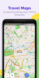
- Map view: Choose from a variety of places to be displayed on the map, such as attractions, food, and health. Easily search for places by address, name, coordinates, or category. Customize the map style to suit your activities, whether it's touring, nautical, winter and ski, topographic, desert, off-road, and more. Enjoy features like shading relief and contour lines.
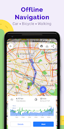
- GPS Navigation: Plan routes to your destination even without an internet connection. The app offers customizable navigation profiles for different vehicles, including cars, motorcycles, bicycles, pedestrians, and more. Easily change the route to avoid certain roads or surfaces. Get real-time information about your route, including distance, speed, remaining travel time, and distance to the next turn.
- Route Planning and Recording: Plot your route point by point using multiple navigation profiles. Record your routes using GPX tracks and manage them easily. Visualize data about your route, including descents/ascents and distances. Share your GPX tracks in OpenStreetMap.
- Creation of points with different functionality: Save your favorite places as favorites for easy access. Use markers to mark specific locations. Add audio/video notes to enhance your experience.
- OpenStreetMap: Make edits to the OpenStreetMap database and contribute to the community. Enjoy frequent map updates, with new data available as often as every hour.
- Additional features: Use the compass and radius ruler for more precise navigation. Access the Mapillary interface for a more immersive experience. Switch to a night theme for easier viewing in low-light conditions. Get information from Wikipedia directly within the app. Join a large community of users for support and documentation.
Conclusion:
With OsmAnd, you can explore the world offline with its comprehensive map view and GPS navigation features. Plan your routes based on your preferences and vehicle dimensions, and record your journeys using GPX tracks. The app offers a range of additional features, including the ability to customize your route, access real-time information, and contribute to the OpenStreetMap community. With its user-friendly interface and frequent map updates, OsmAnd is the perfect companion for all your navigation needs. Download now to start your offline adventure.
- No virus
- No advertising
- User protection
Information
- File size: 121.10 M
- Language: English
- Latest Version: 4.5.10
- Requirements: Android
- Votes: 55
- Package ID: net.osmand
- Developer: OsmAnd
Screenshots
Explore More
Explore the world without leaving your phone! These top-rated travel apps make planning adventures easy and affordable. Find flights and hotels, get maps and guides for cities, learn useful phrases or read insights from locals. Now enjoy armchair sightseeing or turn upcoming trips into reality. Download your passport to global discovery - with premium features free, your next expedition starts here!

100 Animal sounds & pictures

SERP Pokédrock for Minecraft

Tisséo metro tram bus Toulouse

Vaktija

Coral Travel - турагентство

Etransport

Learn German Fast: Course
Horaires Me ! (Paris)


Comment
A Google user
Could use a bit of an update, the app takes a lot of battery especially when on the road. The UI could maybe use a rework too. But overall, the mapping works well for me though, shows almost all of the street names, and the location tracking is pretty good! This definitely is a great alternative to Google Maps though, especially for offline use.
2024-01-04 16:43:11
derp derpstein
OsmAnd is a must when I'm mountain biking. It shows trails you won't find on Google and you can add your own custom markers to the map. The compass feature is a life saver and GPX logging basically leaves a breadcrumb trail on your map. The tracks auto-save so you can look at them again later. I can't believe this incredible app is free!
2024-01-02 07:38:49
Jeroen Trompetter
Works really nice. Configuration may be a bit cumbersome at first, but it's just a matter of time. The only thing that may need improvement is the card rotation when it is set to follow travel direction. It seems to loose it's setting when you stop moving. When you start moving again, you need to tap the GPS image to make it align the screen again.
2024-01-01 07:24:17
ric lamoureux
OsmAnd app has functioned brilliantly for exploration during trail running, cycling, and motorcycling. The off-grid functionality is very useful, as many of the areas I explore do NOT have reliable cell coverage. I also especially appreciate the ability to easily use a GPX track, which I have created on my PC, then sent to my phone. OsmAnd is the easiest to use of the several similar app I have tried. An easy 5 out of 5 stars.
2023-12-31 04:55:06
A Google user
Address search is poor, many street names missing. Sometimes you have to type town then street, sometimes the other way around, sometimes the only way is directly pinpointing a place on the map, which means using other apps. Disappointed with paid version tbh. Free version was shocking in terms of street search. Actual navigation is okay once your destination is set. ETA too optimistic, though. EDIT: I can now get a more realistic ETA by editing the top speed under the car profile settings.
2023-12-30 19:22:13
Joeri Exelmans
Best app for hiking and cycling, especially with the contour lines plugin. I just wish they would update the renderer to something with smoother performance. Scrolling and zooming can be a nightmare. Also i would like if the amount of detail displayed could be "intelligently" determined based on the amount of detail that could be possibly shown: for instance, in a relatively flat area, maybe show a contour line every 10 meters, while for steep areas, maybe every 100 meters. Just a thought...
2023-12-26 12:21:16
A Google user
Thank God, a way better alternative than Google Maps and all the other bad navigational apps out there. I live in an area with horrible cell and gps service, but it seems like this app is magic. I highly recommend downloading all your maps. Their offline mode works 100% without any cell data needed, but you still need an internet connection to download the maps in the first place.
2023-12-25 02:31:44
A Google user
For how I use a GPS, this is by far the best option. I can plan trips on some other desktop app, import those trips as GPX files, and follow them. This is the only app I've found that can do this without you having to jump through hoops. Can record a GPX too and you can share tracks. Lots of options in the app too, well thought out. Slightly steep learning curve, but worth the effort.
2023-12-24 17:10:36
caue rego
there's much more information, in general, at least for Europe, because of the google fear around here... for instance, small rivers. it's messier and harder to use, even if it's already much more complete data wise (not counting street view and aerial view). for sure it'll only get better and eventually be like any other open source project, much superior than all others.
2023-12-22 19:03:39