


Introduction
Ling - แอปเพื่อการเกษตรดิจิทัล is a powerful GIS mapping app designed to assist decision-making in agriculture. With Ling, you will have accurate and up-to-date information at your fingertips, ensuring that important agricultural decisions are never missed. This app allows you to create land maps and calculate land sizes in Thai units, making it easy to share data with stakeholders through platforms such as Facebook, Line, and email. Ling not only solves the problem of outdated or dark maps, but also supports drone-captured images that are clear, detailed, and regularly updated. This app provides precise agricultural data stored in the cloud, allowing users to access information from any device. If you have any suggestions for improvement, please send them to team@lingmaps.com.
Features of Ling - แอปเพื่อการเกษตรดิจิทัล:
* Accurate Agricultural Data: Ling provides precise and reliable GIS (Geographic Information System) maps and data for agricultural purposes. This feature ensures that users can make well-informed decisions related to their farming activities.
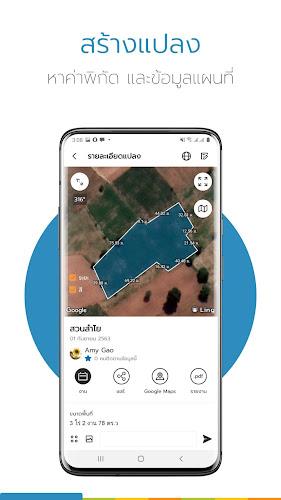
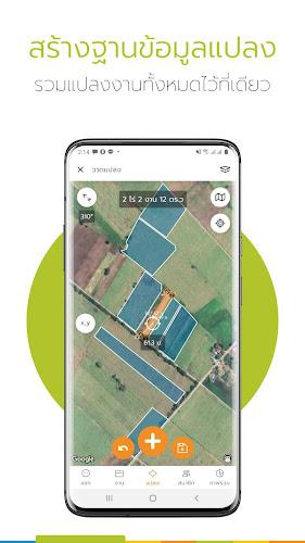
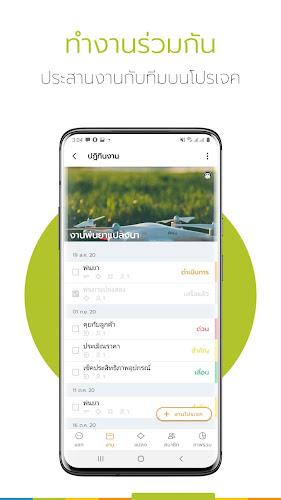
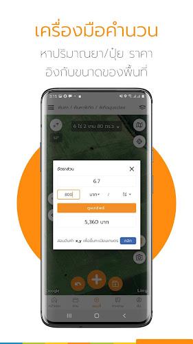
* Land Mapping and Measurement: The app allows users to easily create maps of their land and calculate its size in Thai units. This feature simplifies the process of sharing land data with relevant individuals through various platforms like Facebook, Line, or email.
* Seamless Integration with GIS: Ling seamlessly integrates with GIS data, enabling users to upload and use GIS maps within the app. This feature provides users with valuable information for making informed decisions and choosing the best farming practices.
* Updated and High-Quality Drone Imagery: Ling supports high-quality drone images for mapping purposes. Unlike outdated or blurry maps, drone-captured images are clear, detailed, and regularly updated. This feature ensures accuracy and precision in agricultural work.
* Cloud-Based Data Storage: Ling stores all the agricultural data on a secure cloud-based system. This feature allows users to access their information from any device, ensuring convenience and flexibility.
* User Feedback and Improvement: Ling welcomes user feedback for continuous app improvement. Users can submit their suggestions for enhancement to the dedicated team at team@lingmaps.com. This feature highlights Ling's commitment to providing the best user experience and addressing user needs.
Conclusion:
Ling - แอปเพื่อการเกษตรดิจิทัล is a comprehensive GIS mapping app designed specifically for agricultural purposes. With its accuracy in agricultural data, ease of land mapping and measurement, integration with GIS, updated drone imagery, cloud-based data storage, and user feedback system, Ling offers a valuable tool for accurate decision-making in farming. Download Ling now to experience its precision and ease of use in agriculture.
- No virus
- No advertising
- User protection
Information
- File size: 21.94 M
- Language: English
- Latest Version: v6.5.11
- Requirements: Android
- Votes: 100
- Package ID: com.tig_gis.ling
Screenshots


Comment
A Google user
ไม่มีให้เลือก login ด้วย LINE นะครับ รบกวนตรวจสอบด้วย
2024-04-29 21:16:31
A Google user
เยี่ยมครับ แนะนำเลย
2024-04-28 18:46:10
A Google user
ดีมากๆ
2024-04-28 08:04:35
A Google user
wonderful
2024-04-27 01:19:50
A Google user
should zoom more detail on map. this scale is not suitable for measuring the land.
2024-04-25 13:10:49
A Google user
ใช้ดีครับ
2024-04-25 10:24:16
A Google user
ใช้ดีครับ
2024-04-23 02:40:17
A Google user
เยี่ยมใช้ง่ายมาก
2024-04-23 01:21:40