


Introduction
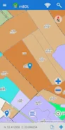
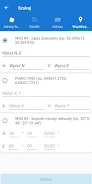
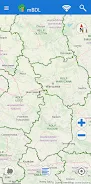
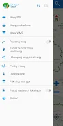
Introducing the mBDL app - your mobile forest data bank! With this application, you can access forest maps directly on your phone or tablet. The app provides various forest thematic BDL maps including basic maps, tree stands, ownership forms, forest habitats, plant communities, hunting maps, tourist development maps, fire hazard maps, and more. You also have the option to display raster backgrounds like topographic or aerial/satellite orthophoto maps. The app allows you to download the necessary data for offline work, making it convenient to use in forest districts and national parks even without an internet connection. In addition to maps, you can access a full taxation description for forests of all ownership forms, with detailed information on species of trees and shrubs, forest addresses, economic indicators, and more. The app also offers functionalities like area and distance measurement, GPS recording, route recording, and navigation. You can export saved waypoints and routes as KML files and easily share them with others. Searching for forest divisions based on forest addresses, cadastral parcels, or coordinates is also possible. Get acquainted with the app's basic functionalities through the provided manual. Download the mBDL app now on https://www.bdl.lasy.gov.pl/portal/deklaracja-mbdl
Features of this App:
- Direct access to forest maps on phones and tablets.
- Forest thematic BDL maps, including basic map, tree stand, ownership forms, forest habitats, plant communities, hunting map, tourist development map, and fire hazard map.
- Option to display predefined raster backgrounds such as topographic map or aerial/satellite orthophotomap, as well as maps from external WMS services.
- Offline functionality allowing the use of maps for forest districts and national parks even without an internet connection.
- Online access to a full taxation description for forests of all ownership forms, including species of trees and shrubs, detailed description, forest address, economic indications, and more.
- Additional functionalities for area and distance measurement, GPS location recording, route recording, and simple navigation to a given point.
Conclusion:
The mBDL App provides convenient and comprehensive access to forest maps and information. With various thematic BDL maps and the option to display additional raster backgrounds and WMS services, users have a range of map choices. The offline functionality allows for continued use even without an internet connection, making it useful in remote forest areas. Moreover, the App offers detailed taxation descriptions for forests, making it an informative tool for forest owners and enthusiasts. The additional functionalities for measurement, GPS recording, and navigation further enhance the usability of the App. Download the mBDL App now to explore and navigate forests with ease.
- No virus
- No advertising
- User protection
Information
- File size: 74.00 M
- Language: English
- Latest Version: 1.19.1
- Requirements: Android
- Votes: 47
- Package ID: pl.gov.lasy.bdl
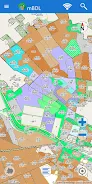
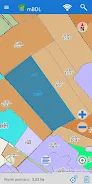
Screenshots


Comment
griphead
Bardzo użyteczna aplikacja, niestety od jakiego czasu prawie zawsze zawiesza się po załadaniu, widoczny jest jedynie interfejs, mapa się nie ładuje, nie da się wykonać żadnej czynności, aplikacja nie odpowiada. Moje urządzenie- Redmi note 8 pro
2024-01-08 22:51:31
Lukasz N.
Kapitalna aplikacja, niezwykle użyteczna podczas leśnych wędrówek. Ma wielki potencjał na bycie must-have do świadomej turystyki. Oprócz naniesienia warstwy ze szlakami, co było proponowane już wcześniej, sugeruję dodanie możliwości 'zafiksowania' północy na stałe - podczas przybliżania/oddalania palcami najczęściej orientacja mapy ulega dewiacji, co wymusza dodatkowy 'klik' aby przywrócić kierunek N.
2024-01-06 14:34:34
A Google user
swietna apka, pomocna
2024-01-05 20:18:20
A Google user
Bardzo fajny pomysł! Można by dodać warstwę ze szlakami pieszymi rowerowymi. Nie włącza też automatycznie lokalizacji.
2023-12-29 08:17:58
Michał Ty
Bardzo przydatna aplikacja, świetne dane, chociaż wykonanie bardziej dla pasjonatów. Np. można wyświetlić sobie wszystkie rezerwaty przyrody, ale nie można dowiedzieć się o nich więcej. Można zobaczyć gdzie są pomniki przyrody, ale nie można zobaczyć nawet typu ani gatunku. Mam nadzieję, że będzie się rozwijać, bo w tych czasach spacery po mało uczęszczanych lasach i polach to świetna i bezpieczna rozrywka.
2023-12-26 01:51:35
A Google user
aplikacja nie działa
2023-12-24 00:14:44
Wiktor Utracki
Fajna apka, użyteczna przy spacerach, poszukiwaniach zrzutów, polowaniach. Zawiera dużo informacji, ma w miarę przyjemny i dość intuicyjny UI. Polecam każdemu kto bywa w lasach
2023-12-14 22:34:46
A Google user
Po włączeniu pokazuje się mapa, można znaleźć swoją pozycję na podstawie GPS ale nie da się pozyskać żadnych informacji o lasach ponieważ dalsze działanie powoduje błąd i wyłączenie aplikacji.
2023-12-14 07:47:14
Andrzej Andrew
very cool and useful app
2023-12-12 05:54:08